We got up early this morning (6 am), had a couple of quick muffins for breakfast, and were driving away from the campground at 7 am. We got to Tag-A-Long Expeditions by 7:15 am as we had been instructed, ready to begin the first of our two scheduled half-day excursions.
However, when we checked in, the woman behind the desk looked at Michelle as though she had two heads. “We left you a message,” she said. Well, of course they left a message on Michelle’s answering machine at home in Kingsburg, so we had no idea what the message said. The woman explained that they switched our excursion schedule, so we didn’t have to be there until 8:45 am. This made us all a little grumpy, because we could have used another hour and a half of sleep.
To kill time, we went to a nearby cafe called Eklecticafe, and had a little pick-me-up. The patio was surrounded with lovely flowers and there were hummingbirds coming and going; it almost blocked out the noise of the cars going by on the main road just a few feet away.
That didn’t take as long as we expected, so we walked around the main street of Moab a bit. There are one or two blocks of cute local shops – bookstores and art shops, along with a few requisite cheesy tourist stores – and we poked our heads into a couple of them.
We were back to Tag-A-Long before 8:45 am as instructed, paid up, and got our gear for the first excursion. We had been expecting to go on a 4X4 excursion in the morning and then rafting the Colorado River in the afternoon. This made the most sense to us – save the wet part for the hot part of the day, and not have wet clothing all day. However, with the switch, we were now going rafting first.
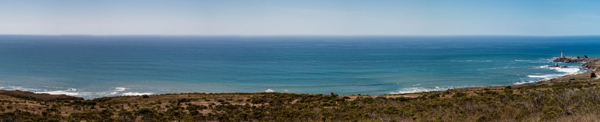
There were 30-40 people on the excursion, and they piled us all into an old schoolbus for the 35 minute drive to the put-in. We drove along State Route 128, which the lead guide informed us is the second most scenic drive in the United States. (Highway 1 in California, aka Pacific Coast Highway, is supposedly #1.) The road winds alongside the Colorado River, which is of course scenic enough. Additionally, there is a spot where the canyon wall looks like an alligator (no joke, but hard to photograph). We also passed a blue heron rookery, a couple of resort ranches, and of course some pretty cool rock formations towering above the adjacent valley.
We got on the river and found ourselves in a boat with a family of 3 adults and 3 pre- and early-teenaged boys. Our guide was the lead guide for today’s trip, a guy in his mid-20s named Will from Connecticut. He confessed to the ten of us that he had chosen us because we’re all English speakers. We had noticed that the majority of the people on the trip were French, and that indeed a large percentage of the people in Moab that day were French-speaking. It’s not so much fun for the guides, because it makes it hard to chat and share information. Not to mention that it’s not very safe in an emergency situation.
What was odd to us is that none of us had paddles. The excursion was called “Scenic Splash”, not whitewater rafting, although we did see a few Class 1 and 2 rapids. It’s common in this part of the river for the guides to row the tourists all the way down the river. There were a few other excursion companies on the river today, and very few boats had non-guides doing any paddling at all.
This was very unfortunately for Will – and for the other guides – because it was EXTREMELY windy today. The wind was blowing upstream at perhaps 30-35 mph, causing whitecaps on the water, and it would have probably blown all the rafts upstream if the guides weren’t rowing so hard. We felt really bad that Will was working so hard, and we were doing nothing. It also made it harder for him to be a tour guide, since he was having to put so much effort into the physical aspects of the job. Apparently, on most days, they can let the river do most of the work.
Besides that, it was a very pleasant float down the river. The scenery was beautiful, and the views from the river are really special. We were able to go in for a swim fairly early on, which was a bit cold at first, but enjoyable. Later, we were invited to body surf a set of (very minor) rapids. Eric chose to do so, but the rest of us stayed in the boat. The few other rapids we encountered weren’t much to talk about – fun, but nothing serious. The wind was a favorable factor for those of us who weren’t rowing – it wasn’t nearly as blazing hot as it might otherwise have been.
We were probably on the river for 2-3 hours. At the end of it, all the guides were completely wiped out. Unfortunately for them, they had to continue along the river with the folks who were on the afternoon excursion. Will told us that he was thinking about cancelling it, because it wasn’t necessarily safe for them to be paddling in those winds, as tired as they all were at that point. But, based on conversations with the guides from the other excursion companies, they apparently decided to continue, because they were already on the river as we drove away in the bus.
Because of the wind, we got to the take-out somewhat later than normal, so we were worried that we might have missed our connection to our 4X4 excursion. As it turned out, we didn’t have to be concerned. As soon as I got off the bus, a guide was asking the bus driver if he knew who was scheduled to be on the 4X4 excursion. I said, “That’s us!” It turned out that we were the only ones on the excursion – hooray for a private tour!
After we gathered ourselves a bit, we all hopped into the vehicle (somewhat ironically, it was a Ford Excursion), and he took us first to the park for lunch. As we ate our sandwiches, we learned a bit about our guide Mike. He was fascinating, and an endless fount of knowledge and opinions about the desert, as well as numerous other topics.
Mike started off by taking us along Highway 313, the road we took yesterday to get to Corona Arch, passing the mysterious Department of Energy site as we turned off Highway 199. He told us the whole story, about how Moab was originally founded as a uranium mining company. The site we now see is one of the nation’s largest Superfund sites, to clean up the uranium and prevent it from getting it into the Colorado River (which, by the way, supplies a great percentage of Southern California’s drinking water – you can draw your own conclusions about that).

The paved road basically ended when we got to the potash processing plant. Mike shared his fascination with the potash mining process, and we quickly became equally intrigued. A few miles up the road (after nearly being nailed by one or two semis on the gravel road) we were treated to views of the potash drying fields, which were a spectacular crystal blue. Mike explained that on a windless day, the ponds are mirrors of the surrounding canyons, which gave us yet another reason to regret the wind.
Mike explained the geology of our surroundings in great detail as we drove through beautiful canyons and vistas. We stopped at one vista called “Thelma and Louise Point”. Indeed it was the site of the final scene in “Thelma and Louise”. Just above us was Dead Horse Point, which we had decided to skip yesterday. The story behind the name is really troubling.
 We continued along the gravel road, crossing a couple of dry creeks that Mike explained are very, very dangerous when there are flash flood conditions. He had a lot of really great search-and-rescue stories, which he was happy to share with us as we drove. We entered Canyonlands National Park about midway through the trek, though there was little change to mark our change in status, other than the fact that there was a small privy there. We continued along and soon came to a high cliff and then proceeded to climb it – the road becoming a series of narrow, steep switchbacks to bring us to the ridge.
We stopped about halfway up the cliff so Mike could show us some dinosaur artifacts. In a recent avalanche, this boulder came loose and came to rest here along the road. Embedded in the boulder were very clear dinosaur fossils, including a chunk of legbone that was at least a foot long, and 3-4 inches in diameter. We were able to touch them and examine them closely – how often do you get to do that? Mike told us that at this spot, as well as some other nearby spots he could take us to, it would be easy for us to poke around and find dinosaur fossils within 15-20 minutes. On top of an adjacent rock, previous visitors had left a few other small fossils they had found nearby. Pretty cool. (Though I couldn’t help remembering the line from Friends, when Phoebe is arguing with Ross about dinosaurs, and she says, “Now the real question is, who put them there, and why?”)
We finished climbing the crazy cliff, and drove along the canyon rim for a bit. We then exited Canyonlands National Park at the Islands in the Sky entrance, where we should have been asked to pay (though it would have been free for me and Dave, Michelle and Eric still had to buy their own park pass), but the fee station was unmanned. At this point we were back on pavement for a bit, until Mike suddenly and without warning swerved to the left onto another gravel road.
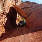 He stopped to show us a vista that he considers to be one of the most breathtaking anywhere, at the top of Long Canyon. It was truly a diverse and expansive view. It also happened to be the spot where Michael Jordan shot one of his Air Jordan commercials. He then drove down a road called Pucker Pass, so named because you feel you have to pucker in order to get your vehicle to fit through the canyon. It was a tight fit, but with Mike’s expert driving, we made it easily. (It would probably be a lot more challenging in inclement weather, though.)
 We made our way down to river level, and stopped briefly to photograph the Jughandle Arch. We continued on and found ourselves back on Highway 313, heading back the way we had originally come. We stopped to examine the petroglyphs on the canyon wall (not far from where we saw the dinosaur tracks yesterday), and Mike did a good job of pointing out the numerous different drawings in various spots along the wall. There really were quite a bit – it would be really interesting to know what thoughts were behind them.
We got back to Moab around 6 pm, having had a relaxing morning on the river and an intellectually stimulating (though orthopedically jarring) afternoon. We returned to camp and had chicken, rice, and veggies for dinner around 8 pm.
 From the time we returned to the campground, we heard loud music drifting over from the high school campus on the other side of the creek from the campground. It sounded like some kind of dance party, and we figured it would end shortly. As it continued to go on, we became more and more curious. After dinner, Michelle and I walked over to see what it was all about. We found that it was a Relay for Life walk around the high school track, to raise funds for cancer research. We overheard the DJ say that it would be going on until 8 am the next morning. We groaned – what were the odds that we would be staying at a campground right next to an all-night cancer walk?!?
It was too early for bed, but too breezy and june-buggy to hang out, so the four of us went to get ice cream at the Moab Diner. It wasn’t the greatest service, but I had some really tasty cherry pie, and in any case it was good to experience a bit of the town. It was only a couple of blocks away, so it was a quick walk back to our campground, and we were in bed by 10:30 pm, listening to the generic DJ music motivating the all-night walkers.