Bay Area, Family Adventures, Uncategorized

NorCal Hikes Suitable for Toddlers & Preschoolers

We have had successful hikes with Leo on these trails… as long as it’s not naptime, and there are snacks and/or clean diapers at the ready. 🙂

Uncategorized

Vancouver vacation

Our 10th anniversary was in 2011, right after we completed a three-week road trip to move to California. We wanted to go someplace special, where we hadn’t already been – but still in the U.S. and reasonably priced. We decided Vancouver was a good choice, since we were in the same time zone and it would be a quick trip.

Unfortunately, before we really started planning the trip, we discovered that Dave’s passport was expired, and we ended up going to the Magic Kingdom (Anaheim) instead.

So finally we went to Vancouver in May 2014. Not an intentional “babycation”, but certainly sure to be our last major vacation just the two of us, for quite some time.

A brief synopsis of our trip, since there’s no time for real blogging (with all the baby planning, appointments, classes, etc in addition to full time jobs and life):

Wednesday, May 14: fly from SFO to Vancouver. Take the Skytrain to our hotel in the West End.

Thursday, May 15: Rest, get oriented. Eat lunch at a place near our hotel called Apple Deli, located in a tiny mall/food court place. Hit up Safeway to buy a few supplies, as we had a kitchen in our hotel room. Walk along the waterfront a bit. Rest some more. Head to the Alibi Room for dinner.

Friday, May 16: Get up at 5:30 am. Take bus to Skytrain to bus to ferry to bus. Finally arrive at Butchart Gardens. Enjoy the gardens for about 3.5 hours (including our sack lunch + some gelato we bought there. Take bus to ferry to bus to Skytrain. Stop at Granville Island and wander a bit, mostly trying to find a place to eat. Eat at The Keg for dinner

Saturday, May 17: Eat brunch at Joe’s Grill in the West End. Walk around the West End and stop by a salon where we both got our eyebrows threaded (Dave’s first time!) Take the bus to Stanley Park and walk around for quite a while. Take a cab over to The Fish Counter to have extremely informal sustainably sourced fish for dinner.

Sunday, May 18: Take several buses plus the Seabus (highly recommend!) to Lynn Canyon. It was beautiful but SO CROWDED. Did quite a bit of hiking and by the end of the trail we were so tired. We took the bus back to Seabus to the bus. Ate a really yummy dinner at Kingyo in the West End.

Monday, May 19: Get a ZipCar near our hotel. Hit up Tim Horton’s for some Timbits and coffee for breakfast. Drive to Lighthouse Park and hike around some ancient Douglas Firs. (So much more chill than the day before.) Drive over to Larson Bay Park to eat our sack lunch while gazing at the water. We decided to just keep driving north, since we had plenty of time and a car, and no other destinations in mind. We stopped at Shannon Falls and walked a bit. We ended up in Squamish, where there didn’t seem to be much to do. We had passed the Sea to Sky gondola, so we went back to see if we could take the gondola ride up, but it was closed for the day. So we headed back to Squamish and walked the estuary trail. Afterward we made a very unsatisfying stop at the local A&W Root Beer, then we drove back. We stopped for dinner in North Vancouver at a pretty tasty and interesting restaurant called Burgoo. On our way home we drove around the west side of Stanley Park which we hadn’t seen earlier in the trip.

Tuesday, May 20: YVR to SFO! Good trip but good to be home.

Uncategorized

Whale Seeking off the NorCal Coast

Pigeon Point LighthouseI didn’t get a chance to post a blog post back in January when Dave and I went on a 3-hour whale watch boat tour. Truth be told, it wouldn’t have been a very interesting blog post, since we saw precisely zero whales. We did have a nice boat ride, the highlights of which were a huge group of California sea lions, some beautiful common murres flying in formation over the water, and a really good look at Mavericks. We made a whole day out of it: drove down the coast afterward, had lunch in Santa Cruz, stopped at Pigeon Point Lighthouse.

I was pleasantly surprised the following Monday when I received an email from the Oceanic Society acknowledging the “regrettable fact” that we hadn’t seen any whales, and offering us the opportunity to reschedule for another tour at no additional charge. Sure, why not?

California Sea LionsSo we set out once again for Half Moon Bay and got on a boat in Pillar Point Harbor with about 40 other people, plus a naturalist and two women from the Marine Mammal Center. As before, the captain of the ship shared that previous trips that week had spotted quite a few whales, and at this time of year it is common to see mother whales with their calves returning from Baja California. We went about a mile and a half out from shore, and headed south.

This time the trip was a bit warmer, slightly less overcast, but fewer sea lions and sea birds overall. We did see harbor porpoises quite a few times – at least, their fins – but they’re really hard to photograph.

CA Coast South of HMBAfter heading south for over an hour, the captain came on the PA system with what had become a familiar announcement: “Well, folks, I don’t know what to say….” He turned toward the coast and started heading north about a half mile off shore. The shoreline on this part of the coast is just beautiful from the water – one would never know from land how cool the cliffs look below.

Thar She Blows!At last, someone spotted a whale! A spout, a little bit of the back… and then the whale dove underwater. The ship stopped to wait, while the captain explained that typically whales stay underwater for 3-5 minutes before coming back up for air. We waited at least 10 minutes before the captain concluded that we must have spooked it. He poked along up the perhaps empty whale highway to see if we could find any of this one’s companions, but no luck. That was our whale spotting for this trip.

Dave and I shrugged, and figured we got 6 hours’ worth of boat rides for the price of three. When we got back to shore, we got into our ZipCar and drove down past Pescadero to the Highway 1 Brewing Company, where we had a very yummy lunch. (Don’t let the menu fool you. It’s a lot of food.)

Pigeon Point LighthouseHeading back up the coast, Dave wanted to stop to get a couple of photos of Pigeon Point Lighthouse as seen from the south. I sat in the car and gazed at the ocean while he darted across the highway to get his shots. As I watched, I saw no fewer than six whale spouts! Dave saw them too, and when he got back in the car, he suggested we drive over to the lighthouse, where there’s a perfect overlook for whale spotting.

Dancing Grey Whale CalfOur luck evened out. There were quite a few whales traversing the whale highway just a few dozen yards from shore. Our timing was perfect – a calf decided to dance out of the water while we watched! We overheard the park rangers a bit later talking about how that was the only whale breech that day. Very exciting! Check out Dave’s sequence photo here.

The lesson learned is that a boat tour doesn’t seem to be necessary to see whales along the California coast, as long as you know where to go. Still, the boat was a fun time.

Uncategorized

Quest for Titans in Jedediah Smith Redwood State Park

Ever since our last visit to Jedediah Smith Redwoods National State Park, I’ve felt a pull to return. The redwoods we visited in Stout Grove were breathtaking, and Smith River calls for me to kayak or raft it.

Redwoods along Mill Creek TrailSo in considering my options for celebrating my 38th birthday weekend, I chose the redwoods. While there are a number of other state and national parks preserving old growth redwood forests, but for some reason I wanted to go back to Jed Smith, despite the fact that it’s the furthest away in the far northwest corner of California.

I did a bit of research on the internet to see what else we might see if we were to return. Stout Grove is lovely but is not enough to merit a 6+ hour drive. A glance at the park map made me wonder if the Mill Creek Trail might be a good option for me. A bit more research led me to learn about the Grove of Titans. From there, I was hooked.

To become more knowledgeable and to get more psyched, I devoured Richard Preston’s The Wild Trees in about a week. I also went to the library and photocopied the redwood section of Robert Van Pelt’s Forest Giants of the Pacific Coast for easy reference while on the trail.

False side trailIn the meantime, I developed pregnancy-induced sciatica at 17 weeks (two weeks before the trip). Suddenly, a 5 mile hike with potential bushwhacking was looking fairly doubtful.

Thankfully, by the time we headed out of town on March 21st, I was able to walk approximately half a mile at a reasonable pace without major pain on a regular basis, so I was determined to do this trip.

So we drove up California’s beautiful North Coast and made it to Jedediah Smith Redwoods State Park mid-day on a Saturday. We came in via Highway 199 and parked near Stout Grove.

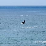
We faced a hurdle right away after we exited Stout Grove at the confluence of Mill Creek and the Smith River. It’s such an amazingly beautiful spot – on a warmer day, I could spend hours just hanging out there. But I was determined to hike the Mill Creek Trail. Unfortunately, the bridge that crosses Mill Creek during the summer is not there during the off-season. We had to take our shoes off and wade through a frigid, up to knee-deep, surprisingly powerful fast-flowing creek to get across to where the trailhead could be found. (The picture Dave took doesn’t do it justice.)

Mill Creek TrailheadIt was a little risky because we couldn’t quite tell from that side where the trailhead actually was. Once we caught our breath and put our shoes back on our damp and slightly sandy feet, we followed the footsteps of earlier hikers across the sand toward the edge of the woods, and found a short set of steps up to the trailhead.


Several trillium growing out of tree trunk
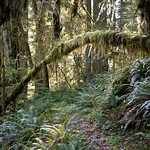
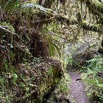
The Mill Creek Trail was the perfect choice. Even without the treasure hunt involved in seeking the Grove of Titans, the trail was lovely. It’s such a joy walking through several miles of a complete redwood grove ecosystem, including sword ferns, wood sorrel, the occasional trillium sprouting out of nowhere, and a variety of other types of trees as well.

Along the trail is a wide variety of redwoods of all ages, as well as interesting botanical sculptures formed by lichen, stumps, and fallen trees. My slow pace created all the more opportunity to take it all in.

Before long, the quest drew nigh. If you Google “grove of titans” you’ll learn that the exact location is intended to be a secret. The internet gives enough hints, though, to indicate that the grove is relatively easily found off the Mill Creek Trail.

We weren’t sure, though, quite how far we would have to go, or just how obvious the side trail would be. So after hiking for about an hour and a half – at a pace that grew slower and slower in half-mile intervals – we started glancing off to the side of the trail to see if we could locate the Grove of Titans.

We did end up bushwhacking a couple of times for a good 10-15 minutes each. I’m still a little surprised that I was able to pull it off, physically. Hopefully we didn’t do too much damage to the underbrush. It must have been very comical, had anyone been watching.

Dave was pretty convinced we hadn’t gone far enough, so once we were back on the trail, Dave sped on ahead to see if he could spot a more obvious side trail, while I poked along.

Finally he came back and described the spot where he thought we might strike gold, but then went ahead again just to see what else might be further down the trail. I came to the spot he described, and it was pretty obvious that it was the right spot. It was even more obvious when a group of 4-5 people plus two dogs (one a fluffy white dog in a backpack) took the turn off the main trail and headed off on the side trail I was standing next to.

Lost Monarch (right) and El Viejo del Norte (left)Dave came back and it was not long before we got the amazing view we’d been seeking: Lost Monarch and El Viejo del Norte, the third and sixth coast redwoods alive. Our quest was successful!

The trail in the grove was a true trail – unlike the false trails that had led to our bushwhacking – though it was a bit overgrown. The folks we followed into the grove got a bit turned around, especially because the larger dog on leash decided she was going to get around however she wanted, trails be damned. We helped them find the trail again, and continued admiring the enormous trees before us.

Jenn with Lost Monarch, Grove of Titans
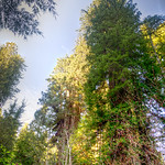
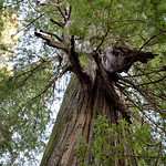
Lost Monarch is truly the more regal of the two largest Titans we found. Enormous but elegant, it’s not really possible to walk all the way around it. Looking up, about a third of the tree is really visible before a cloud of the lower branches obstructs views of the rest of its 320 foot height. I gave the Monarch a hug as requested by Renae.


Screaming Titans, Grove of TitansAs we walked toward El Viejo del Norte, we discovered a network of small paths around the rest of the grove, including what was likely Screaming Titans. (Keep in mind this grove is not on any maps, so the trees aren’t conveniently labeled like, say, the General Sherman in Sequoia National Park’s Giant Forest.)


El Viejo del Norte, Grove of Titans
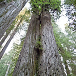
Dave and I lost each other for a bit, as he wandered around taking photos and I stood staring up into the immense trees. Although I had my photocopies from the library, they only described the few largest trees, so they were little help in identifying the others I knew to be named trees in the grove. However, I was able to provide a bit of information to our fellow travelers (one of whom was referring to El Viejo as “El Diablo”). I laid down for a while on a fallen redwood for a while staring up at the intricacies of El Viejo del Norte… and then had a really, really hard time getting back up. Stupid sciatica.

Once we finally found each other, we spent a few minutes trying to find the Del Norte Titan, the largest living coast redwood and supposedly “nearby” in the Grove. We didn’t know what direction to look, though, so we weren’t able to find it. Good reason to go back some day!

Jenn & Dave with El Viejo del Norte, Grove of TitansWe spent a bit more time admiring El Viejo del Norte, the sixth largest living coast redwood and perhaps the gnarliest redwood you’ll ever see. As Robert Van Pelt describes it in Forest Giants of the Pacific Coast, it has a LOT of character.


Tunnel created by fallen redwoodAt that point, I was just about done, but there was still a lot of walking left to do. Dave had also twisted his ankle during our adventure, so we shuffled along the trail for another 30-45 minutes – along trail that continued to be breathtakingly beautiful – until we got to Howland Hill Road.

I could go no further, but the car was parked about 1.5 miles north of where we were, back at Stout Grove. It probably would have taken me about an hour and a half to poke along up the road back to the car, but thankfully Dave had enough energy to power-walk back to the car. I sat on a fallen redwood and flipped through my Birds of California book for 45 minutes while I waited for Dave to come back for me.

We had come full circle. We drove south out of Jedediah Smith Redwoods State Park along the road that had entranced us the first time we visited in July 2009, again listening to Pink Floyd’s “Shine on You Crazy Diamond”.

Check out the rest of Dave’s photos here.

Bay Area

Point Reyes’ Tomales Bay and other Marin/Sonoma Coast adventures

My birthday desire was to go kayaking, so Dave had researched and reserved a kayak tour to see Tule Elk on Tomales Bay at Point Reyes National Seashore.

We got the car around quarter to eight in the morning… a little later than planned. We drove to Marin, and managed to make it to a tiny spot called Marshall by 9:30 am, which is when the tour was scheduled to start.

We checked in, then waited around for a bit to be told what to do. There were a number of other people hanging out, eating donuts, waiting to gear up and get in the water.

After a few minutes, though, the operations manager pulled us aside and asked which tour we signed up for. When we told him, he commented that the Tule Elk tour wasn’t scheduled for that day, but instead was scheduled for Sunday. Had we accidentally signed up for the Sunday tour? He asked if we would be interested in coming back on Sunday, and we told him we had other commitments. He said he would make some calls and figure something out. He promised that we would get to paddle that day.

While he made his calls, we went into the Marshall Store, which isn’t much more than an oyster shack which also sells coffee and a few other snacks. There were a bunch of workers inside getting ready for the day, and they paid us little mind. We got some cash and I bought some tea, and we wandered back in the direction of the kayak place.

The operations manager wasn’t able to find a guide to roust out of bed for a morning paddle, but he offered us the evening paddle, or else a tour around 1 pm. The evening paddle sounded charming, and he assured us that we wouldn’t be too cold. So we made plans to come back by 5 pm.

That meant we had all day to poke around the coast. We started out by driving north just a few miles to a place called Miller Park. While Dave took photos, I enjoyed the site of a pelican dive-bombing into the water. We then spent about an hour taking a leisurely hike along the shoreline, until we got fatigued by picking our way along the rocks.

We continued along Hwy 1 through Tomales, which was impressively busy due to a car show. We continued along to Dillon Beach, drove through the town, and promptly drove out again.

Without any real destination in mind, we decided to continue heading north. Looking at the map, we aimed for Bodega Bay, without realizing we had crossed from Marin into Sonoma County. Not what we were planning when we started out the day!

We needed some guidance, and fortunately we spotted the Sonoma Coast Visitor Center as we drove into the town of Bodega Bay. The woman was quite pleasant and helpful once we explained what we had in mind, and she gave us many good suggestions, both for that day’s adventures and for future opportunities.

We drove around to the inside of the Bay, parked in the parking lot for Westside Regional Park, and set out on a little hike around the point. We spent a few minutes with the gaggle of tourists gathered around the Whale Watch docents. A whale had been spotted very nearby, but Dave and I weren’t able to catch a glimpse. We went for a walk instead, enjoying the sight of the turkey vultures catching drafts off the seacliffs. We got a bit off the beaten path and were surprised by several deer leaping through the bushes.

We went back to the marina and had lunch at the Spud Point Crab Company. The place had a line way out the door when we passed it before our hike, and it hadn’t shrunk much when we stopped to get lunch. The line was well deserved. We had crab sandwiches and chowder, and it was delicious! We really got lucky in where we ended up for lunch.

By this time we were getting pretty fatigued, and we still had a couple of hours before the paddle tour. So we drove back to Miller Park – after all, we had paid for an all-day parking pass – and took a nap in the car for a while.

We got back to Blue Waters Kayaking around quarter to five. We met our guide, as well the other two couples who were also paddling (one of whom included a fellow Hoya, class of 2008).

The evening paddle was mostly peaceful and relaxing. We started out by crossing Tomales Bay, and the wind was a bit tough, but not too bad. Once across, we had a leisurely paddle up the inside of the bay, pausing to admire the sunset, wildlife, and a few historically or geographically significant spots along the way. We saw pelicans, grebes, loons, and ducks. Even better, we caught a few clams spouting water, and saw a bunch of moon jellies! Alas, we didn’t see any river otters, which is what I was really hoping we would catch a glimpse of.

It turned out to be a really nice day! It was great to get out of the city and have an unstructured day out in nature.

Hiking / Backpacking Adventures, Uncategorized

Pinnacles National Park

PinnaclesPinnacles officially became a national park just a month or so ago. Since it’s reasonable driving distance from San Francisco – about two hours – we decided we should take a little day trip. Check out the photos on our Flickr site.

We got a ZipCar and took the 280 south (because it’s usually smoother and more scenic than Hwy 101), which turns into 101. After driving through Gilroy, we got off on Route 25. It goes through Hollister, then winds through rolling foothill ranchlands. This time of year is the best in this part of California, when the hills are actually green instead of golden brown. About 30 miles later we arrived at the turnoff for the East Entrance into the park. From there it only takes a few minutes before getting to the Visitor’s Center.

When we arrived at Pinnacles we found that it was fairly busy. The entrance doesn’t have a drive-through kiosk – you have to park and go into the Visitor’s Center to get a pass. We have a National Park Pass, so all we had to do was show them our pass, and get a receipt to stick in our car.

All of the trailhead parking lots were full, so we had to leave our car in the parking lot and take the shuttle. We ate a quick lunch and then managed to be the last two people on the shuttle. While on the shuttle, I had a nice chat with my seatmate, who was a spry older gentleman who has been coming to Pinnacles with his family for decades. He and his wife gave me some great advice as to how best to navigate the trails we were considering.

The shuttle left us at the Bear Gulch day use area, where there are a number of options for trailheads.

We decided to do the Condor Gulch – High Peaks loop trail, clockwise. It’s over five miles, and reasonably strenuous in parts.

From the trailhead parking lot, there is a short, flat connector trail before the trail starts a steady but reasonable climb to begin the High Peaks Trail. It was a bit steep in places, but then the trail goes along a ridge for a few tenths of a mile. This was a great place for views of both the eastern and western sides of the park.

PinnaclesThe trail then becomes fairly steep, with a series of switchbacks leading up to a rest stop of sorts, where there’s a bench and a restroom. We rested for just a bit, admired the views, and then continued along the trail.

The trail forks here, leading down to the Juniper Canyon Trail, but we continued up and along the High Peaks Trail. The trail became rockier and steeper, and we started to encounter stair steps carved into the rock.

Turkey Vulture at PinnaclesI had been admiring the birds flying around the tops of the rocks, especially a couple of crows flying in pair formations. We got to the top of one spot on the trail and stopped for a bit to watch the turkey vultures soaring around. They were really fun to watch.

We were on the lookout for condors, knowing that one of the gems of Pinnacles is the growing population of California condors that have been released into the wild. As we continued along the trail, we came across a guy with some serious equipment and a “Pinnacles Condor Crew” T-shirt. We inquired about the condors, and he shared that there had been a bunch of them flying around a couple of hours before, but that they had since dispersed. We were a bit disappointed, but we kept a hopeful eye as we continued along the trail.

Narrow Trail at PInnaclesThen we got to the part of the trail labeled “steep and narrow”. There were more stairs, with non-OSHA-compliant handrails. It’s really hard to describe just how steep and how narrow this carved-out-of-rock trail is… you’ll just have to check it out yourself.

We reached another ridge, forked off onto the Condor Gulch Trail, and it was all downhill after that. By “all”, I mean mostly downhill for about 2 miles. it was a relief after so much slow uphill climbing, but on the other hand, our feet got really sore from the pounding!

We reached a spot marked “overlook” on the map, which was not only disappointing, but filled with noisy small children. We didn’t linger; we hit the trail, which was a much flatter downhill slope. We were back to the Bear Gulch parking lot a mile later.

I highly recommend a trip to Pinnacles! There are two reasons why, in my opinion, this park is valuable enough to have been preserved with National Park status. The presence of the California condors, which very nearly went extinct, makes it a very important wildlife preserve. It’s also geologically significant. I’m not much of a geologist, but even I could tell that some pretty interesting activity created the different formations in the park. Less obvious to the layperson is the fact that the San Andreas fault runs right through the middle of the park. (One tourist at the beginning of the trail, when learning this, remarked that it was very unsafe for people to be doing rock-climbing if the fault is running through the park. We were amused.)

It’s also just cool. For those of us who can’t get to Colorado or Utah on a regular basis, Pinnacles is a worthy substitute.

Vacations

Vacation in Carmel: Elkhorn Slough, Moss Landing, and Pacific Grove

Seagull on Monterey BayWhile hiking in Point Lobos, we asked one of the docents where we might be able to get good views of sea otters. She recommended a place called Elkhorn Slough, which she likened to an otter retirement community.

We drove around to the southern side of Monterey Bay to Moss Landing, and managed to find Elkhorn Slough with only a few misadventures.

I was absolutely delighted by the variety of marine wildlife here. There were at least a dozen sea otters, just paddling around in the water. It was particularly fun to watch a couple of them paddle (backward) approximately the length of a football field. The sea otters in Monterey Bay Aquarium don’t have that kind of space!

Just a few hundred yards away was a little beach that was being entirely monopolized by a colony of seals. There must have been several dozen hanging out on the beach, and a few of them playing and swimming in the water. They were almost as much fun to watch, though a little harder to see.

We walked around on the beach and enjoyed watching the numerous species of sea birds, as well as the waves crashing on the beach. It wasn’t particularly sunny, though, and it was a bit windy and chilly, so we didn’t want to bask on the sand.

Before we left, we drove to the other side of the inlet and watched the sea lions that had taken over a dock. There must have been about a hundred of them. They’re always so entertaining on a dock – they’re rolling over each other, grunting, etc. But it was really gratifying to watch them in the water – while clumsy out of the water, they’re really quite graceful when they’re swimming and playing in the water.

I really wanted to go kayaking today, and we really should have gone kayaking here. We would have been able to get an even more eye-level experience with the marine wildlife. We ended up not going kayaking at all, because the weather was so uninviting.

For lunch, we found a mom-and-pop diner called Moss Landing Cafe. It was very chill, pretty cheap, and the food was good (and filling!).

After that, we somehow ended up driving around the Monterey peninsula, and stopped at a few points in Pacific Grove. We saw cormorants, a couple of lone seals, and numerous Marine biologists. A pair of them were tracking a sea otter; another was a guy sitting with his dog in his pickup/office.

Then – the best part! – we saw dolphins out in the water! Maybe they were porpoises – we’re not experts. But it was still pretty cool to watch the pod make its way around the point of the peninsula, then disappear.

Vacations

Vacation in Carmel: Big Sur

Today our aim was to spend some time down the coast in Big Sur.

Bixby Creek BridgeWe got in the car and drove down Route 1. It was so typical – sometimes completely foggy (10-20 feet visibility), sometimes bright and sunny, and everything in between.

We got to Pfeiffer Big Sur State Park to find it warm and sunny. We had a picnic by the Big Sur River, which would have been really peaceful if there weren’t construction workers building a bridge as a park improvement, mere feet from where we were sitting.

The hike I really wanted to do was partially closed, so instead we did the Buzzard’s Roost hike. It started out along the Big Sur River, lush with redwoods, and climbed for a couple of miles. Then, the flora changes very suddenly, and we were surrounded by manzanita (one of my favorites). Fortunately the day was sunny and clear (kinda hot, actually!), so we were able to see the ocean from the top of the trail. The peak wasn’t otherwise scenic, though – the apex featured a small building with a large antenna on top.

We headed back down, and I played in the river just a bit. I wished I had brought my Tevas – then I really would have spent some time in the water.

We drove over to the pat of the park that featured the biggest redwood tree in Pfeiffer Big Sur State Park, the Colonial Tree. We found it to be somewhat underwhelming.

As we left the park, Dave suggested that we check out Pfeiffer Beach. It wasn’t until we got there that we realized that it wasn’t part of the State Park system, so we had to pay another fee (to the U.S. Forestry Service). We made our donation to the federal government, and thankfully were able to get a parking spot.

Whereas it had been very warm just a mile inland, it was chilly and VERY windy on the beach. I was shocked at the people who were sunbathing, and the children playing in the cold Pacific water. The sand was beautiful, but the winds were extreme. There was a cove with some really cool rocks, though, making really interesting breaking waves and tidepools.

As we headed back to Carmel, we took the advice of AAA magazine and checked out a couple of little spots in the Big Sur area. We stopped at a place called Nepenthe, intending to get coffee at Cafe Kevah. Unfortunately, it was closed, but the shop there was open, so we poked around just a bit.

Then we found the Big Sur Bakery & Restaurant, not quite hidden behind a (quaint but very expensive) Shell station. We got cafe mochas, sat on the patio, and watched the cars go by. Very relaxing way to wrap up our Big Sur experience!

Vacations

Vacation in Carmel: Monterey

Today we planned to hang out in Monterey for the whole day and see the sights.

One of the perks of the Degenkolb cabin is two (free!) passes to the Monterey Bay Aquarium. Very exciting – saved us $70!

Monterey Bay AquariumThe trip to Monterey from the Carmel cabin is only about 20 minutes… and we liked it so much we did it twice. (Sarcasm.) We got into the parking garage, paid, and *then* realized that we had left the passes in the cabin. Fortunately the garage was slow, and the guy was nice to us – officially, there are no “in and out” privileges. But, he let us go back, pick up the passes, and come back into the garage without paying twice.

Once in, the Monterey Bay Aquarium was delightful. We gazed at the sea otters for a bit, then headed to the special exhibit called “Jellies!!” It was super – really well designed, fun, and had a lot of different, cool jellyfish. We also enjoyed the “Secret Lives of Seahorses” and then sat for a while staring at the “open sea” exhibit.

At this point it was getting to be lunchtime, so we left the Aquarium and tried out the Cannery Row Brewing Company. It was pretty much what we expected – no complaints.

We headed back to the Aquarium, and saw a few more exhibits. It’s really an awesome aquarium – even better than I remembered it being, the last time I was there (which was third grade!).

By mid afternoon, though, we started to bonk. We left the aquarium and wandered up and down Cannery Row for a bit. We asked ourselves why we were there, when we could have pretty much the exact same experience by going to Pier 39 at home.

For a time out, we headed to the next town over for some Big Box shopping (Target, Kohl’s, etc) – always a treat for us city folk.

We drove back to Cannery Row and found a really great parking spot. We realized just then that it was sunset… so we really should have driven to the west side of the peninsula to see it, before parking and going to dinner. The timing didn’t work out well, though, so instead we tried power-walking in the direction of the sun, to try to catch a good sunset photo. I’m not sure how successful we were, but it was an adventure.

While at the aquarium, we learned a lot about sustainable fishing, which nudged me to ask at the Info Desk where we might find a restaurant that serves sustainably sourced fish. We were pointed toward a place called Fish Hopper, just a couple of blocks away on Cannery Row. It was pretty touristy, and a little overpriced for the quality, but we had a good time anyway.

Vacations

Vacation in Carmel: Point Lobos

Point LobosWe were told by numerous friends that no trip to Carmel is complete without spending time at Point Lobos State Natural Reserve. We were happy to include it in our itinerary. It is a mere 3-4 miles from where we are staying, so it was easy.

Upon entering the park, we drove to the closest picnic spot, at Cannery Point. Pulling up to the parking lot, I looked into the cove and noticed people in the water! I wasn’t prepared for the idea that this would be a scuba diving spot – yet, apparently, it is.

We pulled out our picnic lunch and sat at a table facing the cove. The day had been unexpectedly sunny and clear so far. However, as we ate, we watched a light mist form over the cove, which became more and more solid over the course of twenty minutes.

By the time we were ready to hit the trail, the entire park was encased in fog. I was a little worried at first, because we hadn’t brought jackets or sweatshirts (in fact, Dave was wearing shorts), but as long as we kept moving along during our hike, it wasn’t really cold.

A sign at the beginning of the trail alerted us to the abundant presence of my arch-nemesis: poison oak. I was careful not to touch ANYTHING while I was there. I wish I could have found a way not to breathe, so as not to inhale any of that evil urushiol.