Cross Country Trip

Cross-Country Trip V, Day 12: Utah ~ Dinosaur National Monument

Jenn with dinosaurThe main feature of Dinosaur National Monument is a large quarry that has been excavated by archaeologists and now displays an impressive find of intact dinosaur skeletons found there.

Unfortunately, we were not able to see them.

The visitor center and the overlook to the dinosaur exhibit have been closed for renovation for months, and are scheduled to open in October. In the meantime, visitors aren’t able to see the dinosaur skeletons, and there is a temporary visitor center at the entrance to the park.

The ranger and the volunteers at the visitor center were very helpful, at least. They gave us great information about our campground, other activities to do in the park, and the ranger talk that currently substitutes for the usual fossil viewing.

A shuttle bus takes visitors to the trailhead for the “Discovery Trail“, which is a quick half-mile trail up to a rock face in which several dinosaur fossils are visible. During the renovation, a ranger gives a talk and a mini-tour of the fossils approximately every half hour. They only do this in the morning, though, until 1:15 pm. In the visitor center, they explained that the rangers giving the talk would complain of cruel and unusual punishment if they were required to be out in the desert heat through the afternoon. We were sympathetic to that.

FossilWe joined the ranger talk about 5-10 minutes into the “tour”, just as the ranger was pointing out some of the larger fossils embedded in the rock. We were able to see a femur, humerus, and some other pieces from what may have been one dinosaur. We also saw smaller pieces of various other dinosaurs. It was fairly interesting.

There was also a little side trail, which we walked up after the tour was over. There were some pretty cool quartz rocks on the side of the trail. While looking at some of the fossils and other features along this side trail, we made friends with a family who was also there. We ended up leap-frogging them down the trail, which was actually great, because the dad repeatedly asked the little girl to show us some of the things she had found.

Campground at Green River
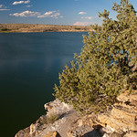
We took the shuttle bus back to the temporary visitor center, got into our car, and drove to the campground. We found a nice shady spot not too far from the banks of the Green River, and had some lunch. We were visited by a very inquisitive chipmunk (which I couldn’t resist calling Alvin), but we chased him off before he grabbed our food.

There is a driving tour in this section of Dinosaur National Monument called “The Tour of the Tilted Rocks“. At the urging of the volunteer in the visitor center, we bought at 50-cent trail guide, which offered explanations for 15 marked spots around the park. We spent about an hour and a half driving around and looking at these various spots.

Petroglyphs in Dinosaur National MonumentSome were more interesting than others. Two spots featured petroglyphs from 1,000 years ago, carved into the “desert varnish” on some of the rock walls. They were quite good, especially a very large, well-defined lizard that could be seen from 100 yards away.

Josie Bassett Morris cabinPerhaps the coolest spot on the tour is the last “stop”. It is the homestead of Josie Morris, a woman who chose to build herself a ranch here in 1914, following her divorce. (Obviously this was before the land became part of the National Park Service.) The lived here until 1964, just before she died at age 90. She was a pretty amazing woman, living a 19th century lifestyle – by herself – so late into the 20th century. The cabin was fairly well intact (though empty), as was her lovely backyard.

After the driving tour, we returned to our campsite and chilled for a while until it got closer to sunset and the temperature started to cool down. We spent a little bit of time in the river, which was cold and swiftly flowing, but a refreshing contrast to the dry hot air.

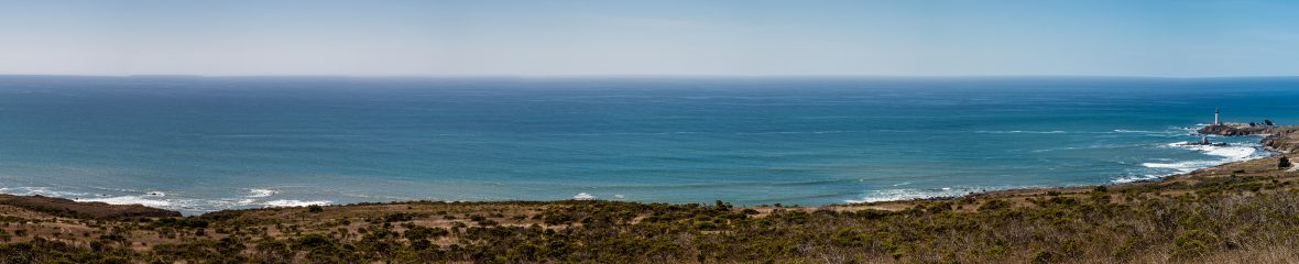
We decided to hike the “Desert Voices” trail, the trailhead for which was at the boat ramp into the Green River. The guide billed the hike as a 2-mile hike, while the trailhead sign claimed that the hike was 1.5 miles. We later determined that the hike was probably 2.5 miles (which is a significant difference, when you’re ending the hike after sunset).

Deer skullWe had a little misadventure right at the beginning, though, which also added to our mile total. At the beginning of the trailhead, there are a few different little trails going in various direction. We got to a fork, which I thought might be the beginning of the loop. I said, “Left or right?” and Dave said, “Right.” So we headed up the trail to the right, which very quickly turned into a little rock climbing adventure. We got some beautiful views of Split Mountain and the Green River. We also saw a well-preserved deer carcass, complete with (separated) head. About 100 feet up, though, we started to doubt that this was the trail. The trail ahead was starting to look like switchbacks to nowhere. We decided we had better climb back down and return to where we had made the fateful “left or right” decision. Fortunately we were only off-track for about 15 minutes.

Once we took the left fork, we found the first interpretive signs for the trail, and learned that the loop didn’t fork until about a quarter mile into the hike. Hmm. Signs are helpful.

Setting Sun Shining Through the GrassThe hike was quite nice. The interpretive signs – some of which were specifically designed for children – were highly philosophical, featuring thought-provoking quotes by Edward Abbey and Henry David Thoreau. It invited thoughts about the importance of the desert, the value of silence, the relative value to society of preserving wilderness. They were pretty interesting.

The hike itself was lovely as well. It went along a wash at the bottom of a canyon for a while, then climbed along the side of some hills for a while, before turning back along the top of the butte and then back down.

Yampa Plateau at sunsetIn the meantime, the sun was setting and the sky was beautiful. About two-thirds of the way into the hike, the sun was basically gone, but the moon was big and bright and beautiful. There was just enough light to keep following the trail, and read those last few interpretive signs, as we finished and got back to our car.

Between our recent hike at Great Sand Dunes and this one, we decided that night hikes are pretty cool.

We went back to the campground and make burritos for dinner. The campground had filled up with campers, but they were reasonably quiet. We were particularly impressed by a large group across the way. When we saw that there were 10-12 tents set up, we lamented that it would probably be a long rowdy night. Instead, they were probably the quietest neighbors we’d had in several nights.

We watched the stars for a little while, noting a few shooting stars, and then headed into the tent for bed.

Cross Country Trip

Cross-Country Trip V, Day 12: Colorado to Utah

This morning we drove from Glenwood Springs to Dinosaur National Monument (which straddles the Colorado-Utah border, but we were heading for the Utah side). We opted for a scenic drive rather than a mostly-interstate drive. It was a good choice.

We did take I-70 to a town called Rifle, and headed north on CO-17 for a little while, and then west on CO-64 for about an hour and a half. The drive was just lovely. For the most part, Highway 64 follows the White River, which is flanked by grazing lands and farms. Mountains rise up on both sides; nothing striking like the fourteen-thousand-footers we saw a couple of days before, but very colorful and beautiful.

For a good half hour I was the only car going west, so I could comfortably go at my own speed without worrying about getting stuck behind a slow vehicle, or having someone behind me wanting to pass. That all changed when I got stuck behind a HOUSE – seriously, it was a pre-fab house on a flatbed, with the “WIDE LOAD” cars behind and in front of it. I was stuck behind the house for over 20 minutes before I finally got an opportunity to pass – but not before I’d slowed down to 25 mph on a short but steep hill.

The rest of the drive was uneventful. We crossed over into Utah, crossed the Green River, and turned off shortly thereafter in the direction of Dinosaur National Monument.

Cross Country Trip

Cross-Country Trip V, Day 11: Colorado ~ Glenwood Canyon Brewing Company

Train station in Glenwood SpringsGlenwood Springs is a cute town. When we drove through on Tuesday evening, coming in from Aspen, the streets were blocked off for a farmers market. (If we hadn’t been so wiped out and focused on getting to the campground, we probably would have stopped to check it out.) The small downtown area is very charming. On Wednesday, after our all-day river excursion (and a nice hot shower), we took a little bit of time to walk around downtown Glenwood Springs. It was hot and sunny, though, so we weren’t motivated to do a lot of poking around.

Glenwood Canyon BrewpubWe were aiming for the Glenwood Canyon Brewing Company. After a couple of nights of campsite cooking, it was nice to have a leisurely dining experience at a decent restaurant. When we were seated, we found that they also had the Yankees game on one of the TVs, so that was a bonus.

Dave had a few of their in-house beers, and I enjoyed a couple of their funky cocktails (including one made with their in-house root beer). We had some soft pretzels as an appetizer, and took our time ordering entrees. We decided to keep it low key – Dave got a burger and I got a salad – but we did splurge and get dessert. It was all quite yummy. The service was good (even when things got busy) and the ambiance was cheerful. It wasn’t too loud, even when the dining room got full.

Cross Country Trip

Cross-Country Trip V, Day 10: Colorado ~ Glenwood Canyon Resort & Campground

We camped for two nights at Glenwood Canyon Resort. We arrived on Tuesday evening just after 6 pm to learn that the riverside camp sites (i.e., the individual camp sites) had just filled. There were group sites available, however, and the woman informed us that some of the individual sites would become available the next day if we wanted to move.

We scoped out the place a bit before making our choice. The “group” sites are a little cheaper ($28 instead of $34). The group sites themselves are actually designed for individual tents, but the grills and firepits are shared (if you wish to use them). They’re not very private, as they’re all lined up next to each other along a fence, but we managed to find one that had foliage on two sides, so we had a little extra privacy.

We drove down to the riverside camp sites to check them out, and found that these had basically no privacy whatsoever. The sites’ “back yard” is beautiful – the Colorado River rushing by with the mountain on the other side – but it really didn’t seem worth the hassle of moving. Plus, when we tried to turn around at the end of the line of campsites, we got stuck in the sand in the boat ramp. It was a scary moment, trying to figure out how to back up without either ending up in the river or gunning it into the rocks on the side of the ramp. Fortunately we figured it out, and returned to the group camp site to pitch our tent and have an early dinner.

When we checked in, we were given coupons to the new “No Name Bar & Grill” there at the resort. As this is the main Wi-Fi hot spot, it seemed like a good idea to get our “buy 2 get 1 free” drinks while accessing the internet. Unfortunately there were no power outlets, so Dave – with his old MacBook’s limited battery life – had to endure “America’s Got Talent” on the bar’s TV while I posted some blog posts and researched some upcoming travel options. At least he got a chance to see UMd’s Gymkana perform.

This is not a particularly peaceful campground. We were quite close to the bathhouse (featuring showers, flushing toilets, and sinks, in addition to a laundry facility) – which was really convenient, but also the site of some hubbub.

When we were getting ready for bed the first night, there was a minor drama involving a boy named Keenan. His mom, her friend, and Keenan’s younger brother were all calling his name and looking for him. He hadn’t been missing for long (actually, Dave and I had seen him about 10-15 minutes before as we fed our laptops some electricity in the laundry room), but his mom was very concerned that he wasn’t responding to their calls. Fortunately it wasn’t long before she figured out that he was hiding in the ladies’ room, for reasons that were unclear. We tried to avert our ears as she gave him a lengthy talking-to about how it’s important to come out from hiding when your mother is frantically calling you.

The second night was even more pathetic. As we were getting ready for bed, there were three people with wine glasses standing at the corner of the bathhouse building (not 40 feet from our tent), loudly discussing whatever topics came to their heads. A bit later, one of the men from that group returned to his campsite, which happened to be the site just on the other side of the trees from our site. He drunk-dialed a friend in Hawaii, and then called another friend in Grand Junction to ask if he could crash at his place for the weekend, “because I’m coming to see my son for the first time in a year”. In the morning, he was on the phone again, calling a guy who was putting him to work building a patio or some such thing. He seemed like a guy really down on his luck… it was pretty depressing to listen to.

Thank goodness Dave brought several sets of earplugs.

Other than the human drama, the campground is decent. The ground was less uncomfortable to sleep on than expected, and it never got as cold as I thought it would be.

Cross Country Trip

Cross-Country Trip V, Day 10: Colorado ~ Aspen

I wouldn’t have gone out of my way to visit Aspen, but since it was on our way, we decided to stop there and walk around for about an hour.

It is exactly what I expected: numerous upscale shops interspersed with mountain gear stores such as Marmot and North Face. There is also a variety of eateries, from McDonalds, to snack shops (chocolate, coffee, ice cream), bars, and restaurants. It is a little too chichi for my comfort, but it was a fun place to walk around for a little bit. And I have to admit that they do make an effort to make it accessible to everyone – the buses are free, there’s a nice park in the middle of the downtown area, and the public bathrooms are among the nicest I’ve ever seen. There was also a nice string quartet playing classical and pops selections not far from the McDonald’s.

Ski mountain at Aspen in summertimeWe walked to the base of the mountain to get a sense of it. I can appreciate how convenient it is to ski right off the mountain and be one block away from all the restaurants and shops. A Starbucks is opportunistically located less than 100 feet from the bottom of the lift.

During the summer, they do offer gondola rides for $25 a pop, which was a little more than we were interested in paying (not to mention that we had only paid for an hour of parking).

We stopped in to the Paradise Bakery for gelato-style ice cream. This made Dave extremely happy, especially since I had made him eat peanut butter & jelly for lunch.

Unfortunately we headed out of Aspen just after 5 pm, giving us the opportunity to experience rush hour traffic from Aspen to I-70. Who puts HOV lanes on the right side of the highway??

Cross Country Trip

Cross-Country Trip V, Day 10: Colorado ~ Scenic drives

We eschewed the interstates today in favor of scenic state route and U.S. highway driving.

Our route took us up CO-17 up to US-285, following the Sangre de Cristo mountains and San Luis Creek. We drove across relatively flat grasslands but were flanked by mountains to the east and west.

Kayaker in SalidaWe took a detour into Salida, which is a mecca for kayakers who want to enjoy the Arkansas River. It is the heart of Arkansas Headwaters Recreation Area, which is a long, thin state recreation area that follows the river. It’s also a really cute community. If I ever learn to really kayak, I’ll have to come back here.

From there, we followed the Arkansas River north to Leadville. On the way, we passed several fourteen-thousand-foot peaks, including the Collegiate Peaks (so named because they include such peaks as Mt. Harvard, Mt. Yale, and Mt. Princeton).

We didn’t really have any purpose for being in Leadville, so we ultimately headed east of town for a picnic lunch at Turquoise Lake.

Dave and Jenn at Independence PassThen came the exciting part of the drive. We headed west on CO-82, passing the highest peak in Colorado, Mt. Elbert. Standing at 14,440, Elbert is the second-highest point in the lower 48 states. (The highest is Mt. Whitney in the Sierras in California, standing at 14,505.) The drive up was just beautiful – following a river valley and winding up the mountains. After a steep climb, we arrived at Independence Pass, at an elevation of 12,093 feet. We stopped and took some photos, admired the view (there was still a bit of snow up there), and breathed in the chilly, thin air.

The way down was a little more harrowing. The road was incredibly narrow at points, and was very winding. It was pretty – following the Roaring Fork River, but the driver doesn’t have much opportunity to admire the view because all focus must be on avoiding collisions with other cars or with the side of the mountain.

Cross Country Trip

Cross-Country Trip V, Day 9: Colorado ~ Great Sand Dunes National Park

Great Sand Dunes National ParkIt was already starting to get warm as we ate our breakfast, admired the hawks circling the lake, and broke camp.

We drove northwest to I-24 and then north, crossing the border from New Mexico into Colorado. We made a couple of stops – first, at a KMart in Raton, NM to buy me some sweatpants (after I realized the next couple of nights would be cold camping), and then in Trinidad, CO to get ice and a few other things at Safeway.

From there it was just a couple more hours to Great Sand Dunes National Park. On our way, we drove past Mt. Blanca, the first “fourteener” we passed, standing at 14,345 feet. (It’s surprising how that doesn’t seem that tall when you’re driving on a road that is already higher than 8,000 feet.)

Great Sand Dunes National Park entranceThe Great Sand Dunes are a unique feature, and the tallest sand dunes in North America. The natural forces that created the sand dunes are well explained elsewhere. What I will add is that it’s impressive how large they are, and how much real estate they occupy at the base of the Sangre de Cristo Mountains. What is also impressive is how many different types of ecosystem there are to enjoy in this park – from alpine peaks and lakes to desert and grassland, and everything in between.

We got a nice spot in the busy campground, pitched our tent, and had lunch as we decided what activities to do in our half day in the park.

Our first stop was the visitor center. It had a 20-minute video that emphasized how the different systems interact with, and interdepend on, each other. It included some beautiful footage of the park in different seasons (noting that few visit the park in the winter), which made us wish that we were there during a wetter time of year. It seems Medano Creek is a pretty fun place to play when there’s water, but it was bone dry when we were there.

Zapata CreekNext we decided to hike to Zapata Falls. Ten miles south of the entrance to the national park is a 3-mile gravel road up the mountain, where there is an overlook (great view of the dunes), restroom, parking area, and trailhead. The trail, while steep, is fairly moderate and short (about 1/2 mile). It was busy but not crowded.

At the top of the trail is a creek. We then had to wade up the VERY cold water, perhaps 150 feet around a couple of bends, until the falls came into view. While not the most impressive or beautiful falls we’ve ever seen, they were pretty cool, especially the way they’ve been carving out the rock for untold numbers of years.

Having acclimated slightly to the freezing cold water, we waded down the creek just a bit. It was really too cold to get completely wet (a shame, since we had purposely changed into our bathing suits, hoping to use the water to cool down from the heat in the desert below), but I did soak my shirt and put it on before we hiked back down to our car. It was completely dry by the time we got to the bottom.

When we got back to our camp site, we had an early dinner, and then headed out to the dunes right around sunset.

Great Sand DunesThe temperature of the sand gets up to about 140 degrees, so it’s not really pleasant to hike them during the day. Once the sun starts to go behind the mountains, though, the surface starts to cool down.

As soon as we began walking on the sand, we realized it would be easier to walk barefoot. We followed the example of others and ditched our shoes at the trailhead, and set across the sand.

Hiking on the Dunes at DuskIf you’ve ever walked on a wide, sandy beach, you can get a sense of what the initial part of our hike was like. For several hundred yards, the ground is flat. The sand is not very fine, and has quite a few pebbles and rocks in it. The part that is *not* like walking on the beach is that there is no water to firm it up, so every step entails another step-and-a-half to continue moving on.

After that, we finally got to the dunes. Just like any set of hills, the near dunes are shorter, and they continue to get taller and taller. According to the Park Service, it takes about 75 minutes to get to the tallest peak. We didn’t feel like we had the energy for that, so we made it to the top of the third dune in, and sat there for a while.

Sand dunes under the starsDave took a bunch of cool night photos of the dunes while I made a sand angel. We enjoyed the stars, the incredibly bright moon, and the surreal landscape. We even saw a couple of shooting stars. (This time of year is the Perseid meteor shower, which wasn’t as spectacular this year because of the bright moon, but it was still possible to see a few.) It became extremely windy, and we realized that it wasn’t really pleasant to sit on top of a sand dune in the wind, so we headed back down.

This place is so cool. It’s really out of the way, but it was totally worth the trip.

Cross Country Trip

Cross-Country Trip V, Day 8: New Mexico ~ Clayton Lake State Park

Clayton LakeWe had pored over our AAA Campbooks and Tourbooks, trying to figure out what our destination should be for this evening. We were aiming for the general area where Colorado, Oklahoma, Texas, and New Mexico all meet. We didn’t want to try to make it all the way to Great Sand Dunes National Park, as it would be dark by the time we got there.

Some online searching turned up a great find: Clayton Lake State Park in New Mexico. We hadn’t expected to go to NM during this trip, but this turned out to be the perfect distance and really a nice spot.

Clayton Lake State Park is a bit north of Clayton, NM. The 12 mile drive winds across relatively flat grassland, and then suddenly you arrive at a butte that overlooks the lake, and the road dead-ends into the campground. The lake is actually a medium-sized reservoir created by a damming Seneca Creek. The campground skirts the south side of the lake. The sites aren’t particularly private, but most of the folks there were day-use folks rather than campers, so we found a nice spot underneath a juniper and pitched our tent.

Dinosaur Tracks at Clayton Lake State ParkThe biggest attraction of Clayton Lake State Park – other than the lake and associated fishing and wildlife – is the dinosaur tracks. At sunset, Dave and I hiked the mile or so from our campground over to the site of the dinosaur tracks. They were made millions of years ago when dinosaurs walked through the mud, which was covered up and preserved until the dam was created. Now, the state park system has built boardwalks around the tracks so visitors can see them up close without wrecking them. I thought they were pretty interesting.

Sunset over Clayton LakeThe rest of the evening was quiet and uneventful. The campground was very quiet, and the stars were beautiful. The weather was perfect, other than a bit of wind, so we slept without the fly on our tent. As we were going to sleep, there must have been a critter dining in the tree above us, because our tent was pelted with juniper berries for a while.

Cross Country Trip

Cross-Country Trip V, Day 8: OKC to NM via Amarillo

It was at this stage in our trip that we left urban settings behind, and headed into the great wide West.

Rest stop BBQ grill in TexasFrom Oklahoma City, we traveled west on I-40 and found ourselves in Texas yet again. About 30 miles into Texas (in approximately Alanreed) we stopped at a fairly elaborate rest area with an overlook to the vast grasslands to the north of it. There were also displays explaining the history of the area and some information about the nearby energy production industry (oil; windmills). It also featured picnic areas with Texas-shaped grills.

We stopped for a late lunch in Amarillo. At the suggestion of a billboard, I got a sudden craving for Mexican food, and Dave managed to find a pretty tasty, authentic place called El Tejavan. I got tacos de carne asada, and Dave got burritos. It was basically a mid-afternoon dinner for us.

As we headed out of Amarillo, we noticed a bunch of graffiti’d cars just off the side of the interstate, and people stopping to get out and walk amongst them. We couldn’t resist. We stopped for gas and then headed backwards to check it out.

Cadillac RanchWhen I first saw it, I thought of it as “Carhenge”. A quick Google search afterward explained that this is Cadillac Ranch, an interactive art installation owned by an eccentric local businessman.

What is most surreal about it is that people bring spray cans to leave their own mark on the cars – even though this will be soon covered up by more layers of paint. It’s quite possible that the paint layers on these cars is now thicker than the original metal body.

The heat drove us back into our air-conditioned car, and we headed west. We soon left the interstate and headed north on two-lane highways that took us into northeastern New Mexico.